The site of Cahokia Mounds is located about 5 miles east of the Gateway Arch in downtown St. Louis, Missouri. The actual historic settlement is bisected by Interstate 55/70 and can be seen from the highway. A beautiful new Interpretive Center awaits visitors, and the site can be hiked by designated trails.
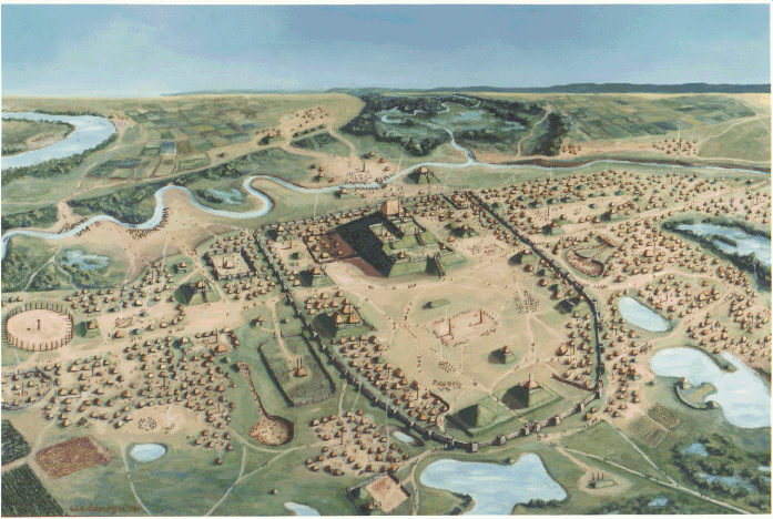
The elaborate site called Cahokia dates back well over 1,000 years and is located in the plain known as the American Bottoms. Over one hundred mounds occupy the land located on the banks of a now-extinct channel of the Mississippi River. The Cahokia site is the largest and most influential settlement north of Mexico. Cahokia is believed to have encompassed over 3,700 square acres (5.8 sq. miles, 15.02 sq. kms.). this is an estimate of the size of Cahokia itself, not including the widespread settlements centered around the city and which can be found as far as 20 miles from the site.
For a view of: the site as
it is believed to have looked
For a look at: the entrance mural
Both photos COPYRIGHT CAHOKIA MOUNDS HISTORIC SITE
(ART GROSSMANN PHOTO EDITIONS)
Cahokia Mounds represents the most complex social and political culture of prehistoric North American aboriginals. The people of Cahokia lived in a very diverse society. Everyone had a specific job in the city and each was equally important. About 40,000 people lived in the city of Cahokia at its peak; however, hundreds of thousands of people were affected by its developments. the community of Cahokia was run by a leader or ruler who may have been a wise elder or an individual who excelled in trade.
Only 109 mounds have now been recorded, but over 120 mounds were originally there. Many have been destroyed or damaged due to farming and urban expansion. The Cahokia Mounds State Historic Site has 68 mounds preserved within its boundaries. the mounds are made of pure earth which was transported by people in baskets on their backs. Most mounds were constructed in stages and even now this is evident to the viewer. Burrow pits are depressions in the ground from which dirt was taken. An estimated 50 million cubic feet of earth was moved for mound construction on the site. If only 68 mounds are preserved within the site and 120 originally existed, then many mounds have either been destroyed or are located on private property where excavation has not been permitted.
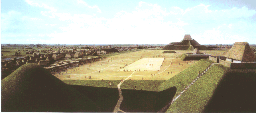
The Cahokians built three different styles of mounds: platform, conical, and ridgetop. Each served different purposes. Platform or temple mounds were elevated bases for the largest and most important buildings. Temples, homes of leaders, and tribal council lodges were probably constructed on platform mounds. Platform mounds were also the most common among the three types. Conical mounds were used for the burial of important people of Cahokia. These mounds may have been grave markers of important people and members of their families, however, most Cahokians were probably buried in cemeteries. The third type of mound, ridgetop, is believed to have been for markers. After all, four of the six ridgetop mounds form a diamond shape directly south of Monks Mound.
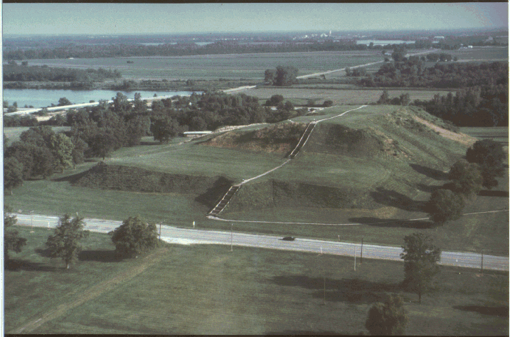
Monks Mound, the largest platform mound at Cahokia is the largest mound north of Mexico and the largest prehistoric earthen construction in the New World. Experts estimate that over 22 million cubic feet of earth was used to create this mammoth mound. It was named for the French Trappist monks who lived nearby in the early 1800's. Over 14 acres are covered by the base of the mound. The leader of Cahokia lived atop this mound in a large building (105 ft. long, 48 ft. wide, and 50 ft. high). From high above he conducted ceremonies and governed the city.
For a view of: Monks Mound
(PHOTO USED WITH THE PERMISSION OF WILLIAM R. ISEMINGER)
Mound 72 is a ridgetop mound and excavation has revealed proof of almost 300 burials. The main burial resembles a man probably in his mid-forties yet most of the burials in Mound 72 are of women. The man was laid to rest on a blanket of more than 20,000 marine shell disc beads. Four male skeletons were found near his body, but the skeletons were missing their heads and hands. Experts believe the men were sacrificed to serve the man in his after life. This is just one of many mass burials found in Mound 72.
A stockade wall 2 miles long surrounded the center of the city. It consisted of a wall of posts set in trenches with guard towers approximately 70 feet apart. The stockade wall is believed to have been constructed four times, and each construction took almost 20,000 logs. The stockade was probably built for defensive purposes, although it may have separated different classes of people. Several sections of the stockade have been reconstructed.
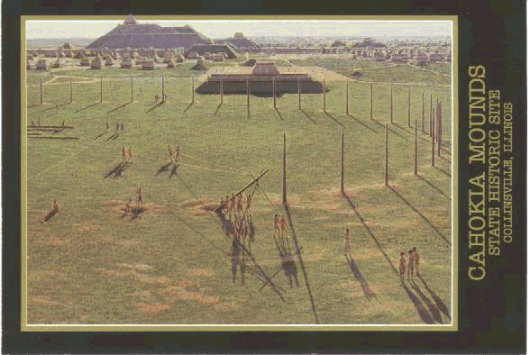
One of the greatest discoveries at Cahokia is Woodhenge. This was names by Dr. Warren Witty who discovered it in 1961. Woodhenge was a giant sun calendar made of evenly spaced log posts. It is formed by a 400 foot circle with the center pole only 5 feet east of the true center. this is a great example of the intelligence level of the Cahokians. The sun calendar more than likely helped determine the changing seasons and specific ceremonial periods. Woodhenge was constructed about 1,000 A.D.
For a look at: Woodhenge
PHOTO COPYRIGHT CAHOKIA MOUNDS HISTORIC SITE
(ART GROSSMANN PHOTO EDITIONS)
Why did the Cahokians decline? This is still a mystery today. Scientists
believe that the decline took place between 1200 and 1400 A.D. Perhaps a climate change
affected crop production which caused people to starve. War, disease, social unrest, and
declining political and economic power may also be reasons. No evidence of epidemic
disease or catastrophic war has been found. It is still a mystery whether southern
colonizers from Mexico brought their ideas to the Mississippi Valley or whether there was
limited contact between the Cahokians and people from the predominate cultures of Mexico.
For additional information read:
1.The Ancient Splendors of Prehistoric Cahokia by Sidney Denny, Ernest
Schusky, and John Adkins Richardson.
2.Explorations into Cahokia Archaeology, Bulletin 7, Illinois Archaeology
Survey.
3.The Great Knob:Interpretations of Monks Mound by Mikels Skele. Studies in
Illinois Archaeology No 4. Illinois Historic Preservation Agency.
![]()